street-segment Component
The street-segment component creates and manages individual street segments in a 3D environment. Each segment represents a distinct part of the street (e.g., drive lanes, bike lanes, sidewalks) with specific properties and behaviors.
User Interface
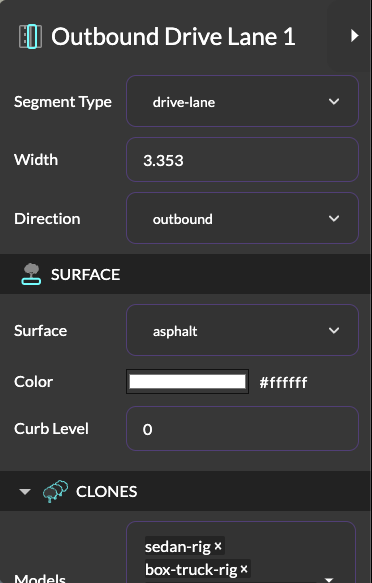
A custom sidebar in 3DStreet Editor allows users to edit a subset of street-segment properties and associated generated components.
Properties
| Property | Type | Default | Description |
|---|---|---|---|
| type | string | - | Type of street segment. Must be one of: 'drive-lane', 'bus-lane', 'bike-lane', 'sidewalk', 'parking-lane', 'divider', 'grass', 'rail', 'boundary' |
| width | number | - | Width of the segment in meters |
| length | number | - | Length of the segment in meters |
| elevation | number | 0 | Vertical offset of the segment surface in meters (0 = road level, 0.15 = curb/sidewalk height). Minimum 0; negative elevations are unsupported. Shown as "Elevation (m)" in the editor sidebar. Replaces the deprecated integer level property (migrated at load time, 1 level == 0.15 m) |
| floors | int | 0 | Boundary building height in floors, carried over from the imported source (Streetmix boundary object). Metadata only for now; it does not yet drive generated building model height. 0 = unspecified |
| slope | boolean | false | Tilt the segment surface between two elevations across its width (Coastmix schema v34). When true, the surface interpolates from slopeStart to slopeEnd and elevation is ignored |
| slopeStart | number | 0 | Elevation in meters at the segment's start edge (local -x, toward the previous segment) when slope is on. Minimum 0 |
| slopeEnd | number | 0 | Elevation in meters at the segment's end edge (local +x) when slope is on. Minimum 0 |
| direction | string | 'none' | Direction of traffic flow: 'none', 'inbound', or 'outbound'. Defaults to 'none' (no travel direction); generated content follows the segment direction only when set to 'inbound' or 'outbound' |
| surface | string | 'asphalt' | Surface material type. One of: 'asphalt', 'concrete', 'grass', 'sidewalk', 'gravel', 'sand', 'cracked-asphalt', 'parking-lot', 'water', 'none', 'solid' |
| color | color | - | Color of the segment surface |
| variant | string | 'custom' | Preset configuration for boundary segments ("Boundary Variant" in the editor sidebar). One of: 'brownstone', 'suburban', 'arcade', 'water', 'grass', 'parking', 'sp-mixeduse', 'sp-residential', 'sp-big-box', 'custom' |
| side | string | 'right' | Which side of the street the boundary flanks ('left' or 'right'). Used with boundary segments |
Segment Types
The component includes several predefined segment types with specific configurations. These are intended to be used as a starting point for creating custom segment types.
Drive Lane
{
  type: 'drive-lane',
  color: white,
  surface: 'asphalt',
  elevation: 0,
  generated: {
    clones: [{
      mode: 'random',
      modelsArray: 'sedan-rig, box-truck-rig, self-driving-waymo-car, suv-rig, motorbike',
      spacing: 7.3,
      count: 4
    }]
  }
}
Bus Lane
{
  type: 'bus-lane',
  surface: 'asphalt',
  color: red,
  elevation: 0,
  generated: {
    clones: [{ mode: 'random', modelsArray: 'bus', spacing: 15, count: 1 }],
    stencil: [{ modelsArray: 'word-only, word-taxi, word-bus', spacing: 40, padding: 10 }]
  }
}
Bike Lane
{
  type: 'bike-lane',
  color: green,
  surface: 'asphalt',
  elevation: 0,
  generated: {
    stencil: [{ modelsArray: 'bike-arrow', cycleOffset: 0.3, spacing: 20 }],
    clones: [{
      mode: 'random',
      modelsArray: 'cyclist-cargo, cyclist1, cyclist2, cyclist3, cyclist-dutch, cyclist-kid, ElectricScooter_1',
      spacing: 2.03,
      count: 4
    }]
  }
}
Boundary
The boundary segment type represents adjacent land use flanking the street: buildings, waterfront, fences, or parking lots. Building variants use the fit clone mode to place buildings continuously along the segment, aligned based on the side property.
Boundary segments never affect street layout: the travelled way (all non-boundary segments) is the only input to centering, ground, and labels. Boundaries render just outside the travelled way's edges by their side, regardless of their position in the scene graph.
This type was previously named building. The old value is deprecated but still accepted; it is renamed to boundary when loading older scenes and JSON blobs.
{
  type: 'boundary',
  surface: 'cracked-asphalt',
  elevation: 0.15,
  generated: {
    clones: [{
      mode: 'fit',
      spacing: 0
    }]
  }
}
Boundary Variants
The boundary segment supports multiple preset variants via the variant property ("Boundary Variant" in the editor sidebar). Each variant defines a specific collection of building models and surface type:
| Variant | Buildings | Surface | Description |
|---|---|---|---|
| brownstone | Mixed 4-5 floor buildings | cracked-asphalt | Urban mixed-use buildings |
| suburban | Single-family houses | grass | Suburban residential homes |
| arcade | Arched buildings | sidewalk | Commercial arcade-style buildings |
| water | Seawall | water | Waterfront edge with animated water |
| grass | Fence | grass | Grass boundary with fencing |
| parking | Fence | parking-lot | Parking lot boundary with fencing |
| sp-mixeduse | StreetPlan mixed-use 2-3 floors | sidewalk | Mixed-use commercial/residential buildings |
| sp-residential | StreetPlan single-family & townhouses | grass | Residential buildings and townhomes |
| sp-big-box | Big box stores, parking structures, government buildings | parking-lot | Large commercial and civic buildings |
| custom | User-defined | - | Preserves custom modifications |
Example with variant:
<a-entity street-segment="
  type: boundary;
  variant: brownstone;
  side: right;
  width: 10;
  length: 150">
</a-entity>
Fit Mode for Clones
Boundary segments use a special fit mode for the street-generated-clones component that intelligently places models based on their actual dimensions:
Properties:
mode: 'fit'- Places models continuously along the segmentspacing- Gap between models in meters (can be negative for overlapping)justifyWidth- Horizontal alignment: 'left', 'center', or 'right'
The component automatically:
- Uses building width and depth from a lookup table
- Calculates positions to fit models end-to-end
- Adjusts horizontal position based on
justifyWidthand segmentside - Stops when remaining space is insufficient
Supported building dimensions are defined for all StreetPlan models, brownstone buildings, suburban houses, and arcade buildings. See the source code for the complete list.
Events
| Event Name | Description | Event Detail |
|---|---|---|
| segment-width-changed | Fired when segment width is modified | {oldWidth, newWidth} |
Generated Components
The component can automatically generate and manage several sub-components based on the segment type:
- Clones: Generates repeated 3D models (vehicles, cyclists, etc.)
- Stencils: Adds road markings and symbols
- Pedestrians: Adds pedestrian models with configurable density
- Striping: Adds road stripes and markings
Surface Types and Textures
The component supports various surface types with corresponding textures:
| Surface Type | Texture ID | Description |
|---|---|---|
| asphalt | seamless-road | Standard road surface |
| concrete | seamless-bright-road | Bright concrete surface |
| grass | grass-texture | Grass surface |
| sidewalk | seamless-sidewalk | Sidewalk texture |
| gravel | compacted-gravel-texture | Gravel surface |
| sand | sandy-asphalt-texture | Sandy surface |
| cracked-asphalt | asphalt-texture | Weathered asphalt surface |
| parking-lot | parking-lot-texture | Parking lot surface |
| water | - | Animated water surface with normals |
| hatched | hatched-base | Hatched marking pattern |
| none | - | No visible surface |
| solid | - | Solid color surface |
Usage
Basic usage example:
<a-entity street-segment="
  type: drive-lane;
  surface: asphalt;
  color: white;
  width: 3;
  length: 150">
</a-entity>
Component Lifecycle
The component manages several key operations during its lifecycle:
- Initialization: Sets up default height and generated components list
- Update: Handles property changes and updates meshes accordingly
- Remove: Cleans up generated components and meshes
Methods
calculateHeight(elevation)
Converts a metric elevation to the segment surface box height (base surface depth + elevation, clamped so the surface never sits below road level).
generateMesh(data)
Creates the segment's 3D geometry and materials.
calculateTextureRepeat(length, width, textureSourceId)
Calculates texture repeat and offset values based on segment dimensions.
Notes
- The component automatically handles elevation changes based on the
elevationproperty (meters) - Texture repeats are calculated automatically based on segment dimensions
- Generated components (vehicles, pedestrians, etc.) are managed automatically based on segment type
- The component uses a custom 'below-box' geometry for proper ground alignment
Known Limitations
- Surface textures and other cloned models must already be present via asset loader, this component does not preload textures or models and assumes they are already available as
mixins in the scene - Negative elevations (below road level) are unsupported:
elevation,slopeStart, andslopeEndhave a minimum of 0 - Slopes can be imported (Coastmix schema v34) and round-trip through save/load, but there is no editor UI for authoring them yet